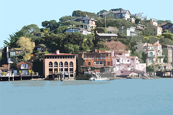
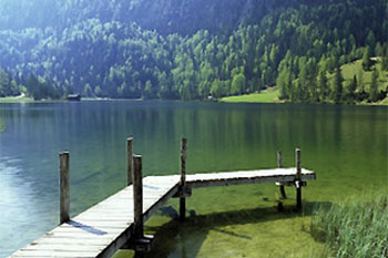
Introduction to Belvedere, California
Belvedere, California, in Marin county, is 7 miles N of San Francisco, California. There are an estimated 2,125 people in the city.
The People and Families of Belvedere
In Belvedere, about 70% of adults are married. Many folks in Belvedere are married and settled down.
The city has a larger percentage of females than most places. Belvedere has its share of retirees. People over 65 are not uncommon.
Wealth and Education
In 2000, Belvedere had a median family income of $185,590. Belvedere has more than its share of wealthy families and people. The city has a large middle class. It’s worth mentioning that smart, educated people feel at home in Belvedere. A tendency for its residents to work at home is one of the things that define the lifestyle in the city. If a good man (or woman) is hard to find, try looking in Belvedere, where there happen to be many singles with good incomes.
Political Inclinations
In the 2004 race for President, John Kerry was the top recipient of campaign contributions ($101,950) in Belvedere. Party contributions tended to flow to the Democratic team.
Belvedere Housing
Approximately 75% of housing in Belvedere is owner-occupied. The city sports a large amount of seasonal housing, typically for vacation or part-time use. Property taxes are a bit high in Belvedere, which may indicate the community’s investment in its schools and infrastructure.
Introduction to Corte Madera, California
Corte Madera, California, in Marin county, is 3 miles S of San Rafael, California and 12 miles NW of San Francisco, California. The town is part of the San Francisco metropolitan statistical area. About 9,100 people live in Corte Madera.
Corte Madera History
Corte Madera was originally inhabited by the Miwok Indians. The town was a part of the original land grant of the Rancho Corte Madera del Presidio. John Reed, a Dublin native received this land grant in 1836. The first ferry service between Yerba Buena and Marin County was started by Reed. During the early 20th century, a number of families from San Francisco settled in Corte Madera. In fact, many of them became permanent settlers after the San Francisco earthquake of 1906. The town of Corte Madera was incorporated in 1916.
Corte Madera and nearby Attractions
Skate Park
Corte Madera Reserve Sanctuary
Aquarium of the Bay
California Palace Legion Honor
Exploratorium
Sausalito Segway Tours
Things To Do In Corte Madera
The town of Corte Madera offers a wonderful view of Mt. Tamalpais. With its beautiful open spaces and a 22-acre park, Corte Madera provides a number of recreational facilities such as hiking, biking, playgrounds, tennis courts, a shopping area and restaurants.
Corte Madera Transportation
San Francisco International Airport is the nearest international airport.
Corte Madera Higher Education
College of Marin is nearby.
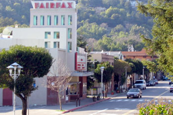
Introduction to Fairfax, California
Fairfax, California is 3 miles W of San Rafael, California and 17 miles NW of San Francisco, California. It is in Marin county. The population of the town is 7,319.
Fairfax History
Dr. Alfred W. Taliaferro was the first settler in the area. He arrived from Virginia, and most likely named the town after Fairfax, Virginia, which was named in honor of Lord Charles Snowden Fairfax.. The Coast Miwok Native Americans inhabited the area before Taliafero arrived. The Fairfax Incline Railway arrived in the city in 1913. The first school in Fairfax was built in 1908.
Fairfax and nearby Attractions
San Francisco Museum of Modern Art
Asian Art Museum of San Francisco
Camron – Stanford House
Muir Woods National Monument
Agate Beach County Park
Samuel P. Taylor State Park
Things To Do In Fairfax
Local parks include the John F McInnis County Park, Paradise Beach County Park, the Charles Lee Tilden Regional Park and the Tomales Bay State Park. Museums nearby include the Cable Car Museum, the USS Hornet Museum, the Habitot Children’s Museum and the Contemporary Jewish Museum. The Petaluma Adobe State Historic Park, the Alvarado House and the Fort Point National Historic Site are all located in Fairfax as well. The Seventh Day Adventist Church, the Fairfax Community Church and the Saint Ritas Roman Catholic Church are some of the local houses of worship.
Fairfax Transportation
San Francisco International is the nearest major airport.
Fairfax Higher Education
One can pursue higher education at Contra Costa College, the College of Marin and the University of California-San Francisco.
Introduction to Greenbrae, California
Greenbrae (sometimes, Green Brae) is a small community in Marin County, California. It is located 1.5 miles (2 km) south-southeast of downtown San Rafael, at an elevation of 33 feet (10 m), located adjacent to U.S. Route 101 at the opening of the Ross Valley. Part of Greenbrae is an unincorporated community of the county while the remaining area is inside the city limits of Larkspur. The ZIP code is 94904, and is shared with the neighboring CDP of Kentfield. The community is in area code 415.
Predominantly composed of hillside and waterfront terrain, its homes and offices are known for their views of the San Francisco Bay, Corte Madera Creek, and Mount Tamalpais. The developer of Greenbrae, Niels Schultz, Jr., died in early 2008. Greenbrae’s neighborhoods are bordered by downtown Larkspur to the south, Larkspur Landing to the east, the unincorporated area of Kentfield to the west, and the city of San Rafael to the north. Straddling Sir Francis Drake Boulevard, its most frequented points of interest include Marin General Hospital and Bon Air Shopping Center.
Greenbrae was home to U.S. Senator Barbara Boxer for over 30 years, until 2006.[citation needed] Football coach Pete Carroll was raised in Greenbrae.[4] Writer Jack Finney died in Greenbrae shortly after completing his last novel, as did Les Crane.
Director Don Siegal filmed the final scenes from the 1971 movie Dirty Harry on Greenbrae’s East Sir Francis Drake Boulevard. After hijacking a school bus “Scorpio” (Andy Robinson) drives into East Sir Francis Drake Boulevard at the Greenbrae interchange. The final shootout scene in the 1971 film, was located on the old gravel mill (Hutchinson’s Rock Quarry) that became what is now Larkspur Landing.
Introduction to Kentfield, California
The place was founded by James Ross as Ross Landing. Steamers would come up the Corte Madera Creek to the landing there. Albert Emmet Kent bought the land from the Ross estate in 1871. Kent built an estate called Tamalpais, later applied to the settlement by the railroad. The named was changed to Kent in the 1890s, and finally to Kentfield with the opening of the first post office in 1905.
Demographics
As of the census of 2000, there were 6,351 people, 2,506 households, and 1,806 families residing in the CDP. The population density was 2,119.5 people per square mile (817.4/km²). There were 2,565 housing units at an average density of 856.0/sq mi (330.1/km²). The racial makeup of the CDP was 94.54% White, 0.35% Black or African American, 0.17% Native American, 2.14% Asian, 0.11% Pacific Islander, 0.46% from other races, and 2.24% from two or more races. 2.22% of the population were Hispanic or Latino of any race.
There were 2,506 households out of which 34.2% had children under the age of 18 living with them, 62.3% were married couples living together, 7.6% had a female householder with no husband present, and 27.9% were non-families. 21.5% of all households were made up of individuals and 8.4% had someone living alone who was 65 years of age or older. The average household size was 2.52 and the average family size was 2.94.
In the CDP the population was spread out with 25.0% under the age of 18, 3.4% from 18 to 24, 22.0% from 25 to 44, 32.9% from 45 to 64, and 16.7% who were 65 years of age or older. The median age was 45 years. For every 100 females there were 93.7 males. For every 100 females age 18 and over, there were 88.9 males.
The median income for a household in the CDP was $117,457, and the median income for a family was $154,673. Males had a median income of $88,000 versus $59,286 for females. The per capita income for the CDP was $79,459. About 2.8% of families and 3.7% of the population were below the poverty line, including 4.7% of those under age 18 and 1.9% of those age 65 or over.
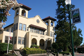
Introduction to Larkspur, California
Larkspur, California is 2 miles S of San Rafael, California and 12 miles NW of San Francisco, California. It is in Marin county. The city is part of the San Francisco metro area. The population of Larkspur is 12,014.
Larkspur History
In its early days Larkspur stood out due to its Volunteer Fire Department. This fire department was started in 1906 with one horse cart by the people of the city. The city of Larkspur was incorporated in March 1908. The following month it had its first election.
Larkspur and nearby Attractions
Muir Woods National Monument
Golden Gate Bridge
Aquarium of the Bay
Alcatraz Island
Palace of Fine Arts
Grace Cathedral
Things To Do In Larkspur
The city has several parks which provide facilities for picnicking, sports and other recreational activities. The recreational department of the city regularly organizes various events and activities for the entertainment and personal development of its population.
Introduction to Mill Valley, California
Mill Valley, California, in Marin County, is 4 miles S of San Rafael, California (center to center) and 11 miles NW of San Francisco, California. The city benefits from easy access to the nearby cities and towns with which it shares the San Francisco metropolitan area. Mill Valley contains a population of approximately 13,600.
Mill Valley History
The area that has developed into Mill Valley was originally received by John Thomas Reed as a Mexican land grant. Reed, who was Irish, became a citizen of Mexico in 1834. He constructed the first saw mill called the “Old Mill” in California. This mill provided the fire for initial growth of the area which began to develop rapidly during the Gold Rush and is now an affluent residential community.
Mill Valley and nearby Attractions
Tea Garden Springs
Fisherman’s Wharf
Muir Woods National Monument
Kabuki Springs & Spa
Nob Hill Spa-Huntington Hotel
Things To Do In Mill Valley
Mill Valley has number of parks which offer facilities for recreation, as well as fitness activities and sports. There is a golf course, as well as tennis courts for the lovers enthusiasts of these games. Additionally, the Mill Valley Parks and Recreation department regularly organizes various events and activities.
Introduction to Novato, California
Novato, California, in Marin county, is 9 miles SE of Petaluma, California (center to center) and 24 miles N of San Francisco, California. It’s part of the San Francisco Bay Area. Fireman’s Fund Insurance Company and several biotech firms are located in the city. Notable companies located at the former Hamilton Air Force Base include Sony Imageworks, Smith & Hawken, Birkenstock Distribution USA and Visual Concepts Entertainment. Rolling hills, cow farms and numerous ranches are located near the western portion of the city.
Novato History
The area originally included several Coast Miwok villages. The city was established in 1839 as Rancho de Novato by a land grant by the Mexican Government. Four additional land grants were created in the area. During the middle of the 1850's Joseph Sweetser and Francis De Long purchased a large acreage and developed orchards and vineyards.
The railroad arrived in 1879 and connected the city with Sonoma County. During the Great Depression a large number of farmers lost their land. After World War II a vast number of homes were built. The city was incorporated in 1960. The Hamilton Air Force Base was decommissioned in 1974 and now includes homes and office buildings.
Novato and nearby Attractions
Miwok Park/Marin Museum of the American Indian is a notable venue.
Novato Arts Center at Hamilton Field.
Novato History Museum.
Novato Old Town features unique shops and attractive historic buildings.
Novato Activities
Stafford Lake is popular for fishing and picnicking and includes a scenic nature trail. The nearby Muir Woods is a well known scenic location and features the impressive coast redwood trees. Residents and visitors enjoy touring the nearby wineries located in Napa and Sonoma and the Pacheco Ranch Winery located in Novato. Samuel P. Taylor State Park features grasslands and coast redwood groves. The close by scenic Point Reyes, situated along the coastline features a vast number of bird species, a historic lighthouse, panoramic views, a variety of landscapes and scenic walking trails.
Olompali State Historic Park offers scenic views. Mt. Burdell is popular with hikers. Golf enthusiasts enjoy playing at the scenic Indian Valley Golf Club and the Stone Tree Golf Club. San Francisco is about a thirty minute drive away. The scenic Mount Tamalais State Park includes redwood trees and spectacular views. The beautiful and charming city of Sausalito, situated along the San Francisco Bay is a popular tourist location.
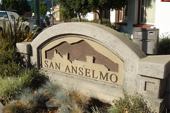
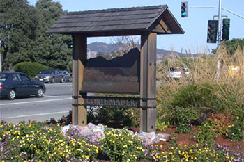
Introduction to San Anselmo, California
San Anselmo, California, in Marin County, is 1 miles W of San Rafael, California (center to center) and 15 miles NW of San Francisco, California. The people of the town reside within the San Francisco metropolitan area. San Anselmo has a population of 12,378.
San Anselmo History
San Anselmo was named after the Punta de Quintin land grant, which deemed this area the Canada del Anselmo, meaning the Valley of Anselm. It used to be a capital for silent films in the early years of the twentieth century. The area was incorporated in 1907 and was officially declared a town in 1974.
San Anselmo and nearby Attractions
Elder’s Garden at Memorial Park
Montgomery Chapel
Robson Harrington House & Gardens
Log Cabin at Memorial Park
Tamalpais Building
Things To Do In San Anselmo
San Anselmo is recognized as a hub city because of its location. The city has several lakes, and trails, as well as a number of parks that offer facilities for various sports, as well as rest and recreation. Mountain biking, antique hunting, fine dining and organic farming are some of the popular activities in this area.
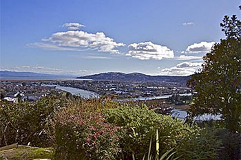
Introduction to San Rafael, California
The California city of San Rafael, county seat of Marin County, is located 17 miles north of San Francisco in the North Bay region of the Bay Area. The city is bordered by San Pablo and San Francisco bays and lies near the junction of Interstate I-580 and U.S. Route 101. Neighboring communities include Santa Venetia (to the north), San Anselmo (to the west), and Greenbrae (to the south).
San Rafael is one of several California towns which developed around a Spanish mission in the California mission chain. Mission San Rafael Arcangel, built in 1817 and rebuilt in 1949, was the 20th in the mission chain and was named for the Archangel Raphael, the Angel of Healing. One of California’s original 27 county seats, San Rafael became Marin County’s first city when it was incorporated in 1874. The oldest, largest, and most culturally diverse city in the county, San Rafael is today a lively industrial and cultural center located in an area replete with natural beauty. The city is home to Dominican University.
San Rafael Attractions
Approximately 30 percent of San Rafael’s land is comprised of parklands and open space, making many recreational activities available. China Camp State Park is a quiet and beautiful venue whose 1,600 acres provide ample opportunities for hiking, biking, and overnight camping. The park acquired its name from a Chinese fishing village that once flourished there. The city is also home to a number of historical and cultural attractions, including the following:
Rafael Film Center: A restored Art Deco Film Center which originally opened its doors in 1918 as The Orpheus is now a year-round venue showcasing independent and international films as well as film retrospectives.
Marin County Civic Center: The last major commission of legendary architect Frank Lloyd Wright and also one of his most distinctive designs, the facility houses Marin Center, the county’s largest performing arts and convention facility.
Marin Historical Society Museum: Located in Boyd House, a beautiful example of high Victorian Gothic set in a park-like garden, the museum contains a detailed collection of local historical photos and artifacts.
Falkirk Cultural Center: Housed in a 17-room mansion built in 1888, the former home of Scottish shipping magnate Robert Dollar, the facility now exhibits contemporary art and sponsors year-round events with other cultural organizations.
Dominican University: Founded in 1890, the university is situated on 80 wooded acres in the center of San Rafael.
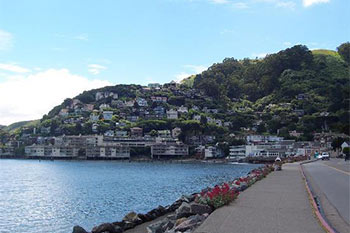
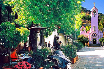
Introduction to Sausalito, California
Sausalito, California, in Marin county, is 6 miles NW of San Francisco, California. The city is home to some 7,330 residents.
Sausalito History
Sausalito is located in Marin County, which was created on February 18, 1850. The city name was adopted from the Spanish word for “little willow grove.” The Miwok Native Americans were the first settlers in the area. The first railroad arrived in the city in the 1870s. Don José de Cañizares became the first European to visit the city on August 5, 1775.
Sausalito and nearby Attractions
Bay Area Discovery Museum
Martinez Historical Museum
John Muir National Historic Site
Benicia Capitol State Historic Park
Paradise Beach County Park
Agate Beach County Park
Things To Do In Sausalito
Local parks include the Charles Lee Tilden Regional Park, the San Bruno Mountain State Park, the Angel Island State Park and the McNears Beach County Park. Local museums include the Treasure Island Museum, the Cartoon Art Museum and the Habitot Children’s Museum. The Christ Episcopal Church and the Star of the Sea Roman Catholic Church are the local houses of worship.
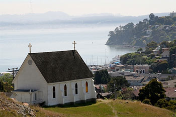
Introduction to Tiburon, California
Tiburon, California, in Marin county, is 7 miles N of San Francisco, California. The town has a population of 8,666.
Tiburon History
Tiburon was founded on February 18, 1850. The area was originally inhabited by Native Americans. The name was adopted from the word tiburón, meaning shark in Spanish. Tiburon was incorporated as a city on June 23, 1964. The North Pacific Railroad arrived in the city in 1882.
Tiburon and nearby Attractions
Bay Area Discovery Museum
Oakland Museum of California
John Muir National Historic Site
Benicia Capitol State Historic Park
Point Pinole Regional Park
McNears Beach County Park
Things To Do In Tiburon
Local parks include the San Bruno Mountain State Park, the Agate Beach County Park, the John F. McInnis County Park and the Samuel P. Taylor State Park. Local churches include the Tiburon Baptist Church, the Old Saint Hilarys Church and the Community Congregational Church. Tiburon is home to the Boardwalk Shopping Center, the Cove Shopping Center and the Ark Row Shopping Center. Local museums include the Treasure Island Museum, the Bay Area Discovery Museum and the Habitot Children’s Museum.
Introduction to West Marin
Point Reyes Station (formerly, Marin and Olema Station) is small unincorporated town located in western Marin County, California. Point Reyes Station is located 13 miles (21 km) south-southeast of Tomales, at an elevation of 39 feet (12 m).[2] Point Reyes Station is located along State Route 1 and is a gateway to the Point Reyes National Seashore, an extremely popular national preserve. About 350 people live in the town. It is also the name of a census-designated place in northern California covering the unincorporated town and surrounding countryside, with a total CDP population of 818.
The town is home to the region’s weekly newspaper, The Point Reyes Light, which won the 1979 Pulitzer Prize for Public Service for its reporting on the now-defunct cult group Synanon. Now, under new ownership and editorial staff The Point Reyes Light has competition from the West Marin Citizen.
Demographics
As of the census of 2000, there were 818 people, 352 households, and 218 families residing in the CDP. The population density was 225.1 people per square mile (87.0/km²). There were 373 housing units at an average density of 102.6/sq mi (39.7/km²). The racial makeup of the CDP was 92.05% White, 0.61% African American, 0.12% Native American, 0.24% Asian, 0.12% Pacific Islander, 3.91% from other races, and 2.93% from two or more races. Hispanic or Latino of any race were 9.29% of the population.
There were 352 households out of which 27.3% had children under the age of 18 living with them, 49.1% were married couples living together, 8.2% had a female householder with no husband present, and 37.8% were non-families. 29.8% of all households were made up of individuals and 13.6% had someone living alone who was 65 years of age or older. The average household size was 2.28 and the average family size was 2.83.
In the CDP the population was spread out with 19.3% under the age of 18, 7.1% from 18 to 24, 23.1% from 25 to 44, 35.8% from 45 to 64, and 14.7% who were 65 years of age or older. The median age was 45 years. For every 100 females there were 85.1 males. For every 100 females age 18 and over, there were 82.3 males.
The median income for a household in the CDP was $57,292, and the median income for a family was $69,821. Males had a median income of $41,181 versus $38,269 for females. The per capita income for the CDP was $39,339. About 6.0% of families and 6.6% of the population were below the poverty line, including none of those under age 18 and 15.5% of those age 65 or over.